
El Niño Storms Reach California: Protect the Coast and Burn Scars
El Niño is now the strongest on record for this time of year, and California’s worst coastal flood risk runs from late November through late January, when king tides peak. Burn scars and stripped beaches leave less margin than usual, so agencies, contractors and homeowners should get protection in place before the next storm.
California’s most widespread storm of the fall arrived this week. The atmospheric river was forecast to drop 1 to 3 inches of rain across Southern California, with 3 to 5 inches on some mountain slopes, according to CNN Weather. Before it hit, Los Angeles County issued evacuation warnings for the Palisades, Hurst and Sunset burn scars.
More weather is on the way. The Climate Prediction Center’s hazards outlook shows a moderate risk of heavy rain over northern California and southwestern Oregon on November 24–25, along with heavy snow in the northern Sierra and high winds on the coast. The worst coastal flood risk of the season starts now and lasts into late January.
We covered the national outlook in our September look at Super El Niño flooding. This update covers California, where the season has already started.
The Strongest El Niño on Record for November
As of early November, this El Niño is the strongest on record for this time of year by the Oceanic Niño Index. That comes from the November 2026 update by Daniel Swain, a climate scientist with the University of California’s Institute for Water Resources. He gives it better than an 80% chance of becoming the strongest on record by NOAA’s relative index.
The effects already show along the coast. Ocean temperatures are 8 to 10°F above average from Point Reyes to past San Diego, and water levels are running as much as 1 to 2 feet above predicted tides.
Governor Newsom declared a statewide state of emergency on September 21. The proclamation mobilizes state resources and streamlines procurement for El Niño preparation.
The Coast Lost Ground Before Winter Began
Tropical swells and high tides damaged Southern California’s shoreline in September and October, before the rainy season started.
- Crystal Cove State Park: Waves exposed utilities and broke a waterline to a historic cottage. Guests were evacuated and most reservations were suspended at cottages that have had about $70 million in restoration work.
- San Clemente: A seven-mile stretch of railroad closed after waves hit an embankment that had lost its sand. The line carries about $1 billion in freight each year.
- Long Beach: Cracked homes at risk of collapse prompted evacuations.
- Laguna Beach: A cliffside fracture partially closed a section of Pacific Coast Highway.
- Newport Beach: High surf breached protective berms.
Sea level has run about 6 inches above normal since March, and researchers expect another 6 inches in the coming months. UC Irvine engineering professor Brett Sanders expects “the most stressful winter we have had in a number of years” for waves.
Late November Through January Is the Danger Window
Swain puts the highest coastal flood risk between late November and late January, during king tide season. If a storm arrives on a king tide, he warns, major and possibly record-breaking erosion and flooding could follow. Inland flood risk peaks later, from December through March.
Past strong El Niños show what can happen. In the 2015–16 winter, erosion across 29 West Coast beaches ran 76% above normal, and most California beaches eroded past their historical extremes. How much sand a beach had going into that winter strongly shaped how much it lost.
The 1997–98 winter led to disaster declarations in at least 27 California counties, and some Monterey Bay beaches lost up to 13 feet of vertical sand, according to USGS. USGS later noted that some beaches took a decade to recover.
This fall’s storms have already stripped sand from many Southern California beaches, which leaves less of a buffer against winter waves.
Burn Scars Need Far Less Rain to Fail
Burned ground needs much less rain than unburned ground to start a debris flow. In Southern California, as little as 0.3 inches of rain in 30 minutes has triggered debris flows, according to the USGS. Any storm that rains harder than about 0.4 inches per hour carries risk.
Some of the largest debris flows happen in a burn scar’s first storm season, and they become unusual after the second. Scars from the January 2025 fires are entering their second rainy season, and any newer scars are entering their first. A wet winter raises the risk for both.
What to Do Before the Next Storm
Public agencies and coastal managers
- Order barriers now, before king tides peak. The governor’s proclamation streamlines state procurement for El Niño preparation.
- Survey beaches and bluffs against their post-September condition to find the thinnest stretches.
- Stage protection at exposed rail embankments, coastal roads, utilities and historic structures.
- Clear debris basins, culverts and storm drains below burn scars, and review other ways to prevent mudslides in California.
Engineers and contractors
- Protect active coastal and creekside sites with perimeter flood barriers or cofferdams.
- Set crest heights for water levels 1 to 2 feet above tide tables.
- Plan equipment access ahead of time, since storms can close coastal roads.
Property owners
- Check whether you live in a burn scar evacuation zone and sign up for county alerts.
- Never drive through floodwater.
- Protect garage doors and other low entry points before the rain starts. Our guide to garage door flood barriers covers options for homes.
- If you plan to buy flood insurance, buy it now. Most new NFIP policies take 30 days to take effect.
How TrapBag Helps
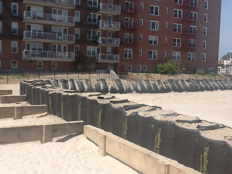
California agencies already use TrapBag on this coastline. At Crystal Cove, California State Parks crews installed 50-foot TrapBag sections as a buffer against rising tides. At El Moro Beach, Caltrans District 12 protected the shoreline with TrapBag, installed by Ortiz Enterprises, Inc.
TrapBag barriers are self-supporting cells that come in 50-foot sections and connect to one another. Crews fill them on site with sand, gravel or native soil, using up to 50% less fill than sandbags, and heavy equipment can install them within hours. The barriers stand up to years of UV exposure.
Agencies and contractors use TrapBag for dune stabilization, seawall reinforcement, mudslide and mudflow protection below burn scars, and cofferdams for active sites. For homes, the Aluminum Plank System and Water-Filled Barriers protect doors and entries.
Storms are already reaching California. To plan protection before the next one, call TrapBag at (239) 674-6611, available 24/7, or contact our team.
Frequently Asked Questions
Does El Niño guarantee a wet winter in California?
No. El Niño shifts the odds but doesn’t guarantee any one storm, which California also said when it declared its emergency. Swain’s November update shows a much higher chance of a wetter-than-average rainy season statewide and higher odds of heavy rain events.
When is coastal flooding most likely this winter?
From late November through late January. King tides fall in that window, and coastal water levels are already as much as 1 to 2 feet above predicted tides. A storm that arrives during a king tide carries the highest risk of major erosion and flooding.
How much rain triggers a debris flow in a burn scar?
In Southern California, as little as 0.3 inches of rain in 30 minutes has triggered debris flows, and any storm above about 0.4 inches per hour carries risk. Debris flows are most likely in a burn scar’s first two rainy seasons.
Get the Dirt Before the Flood Hits
Stay ahead of flooding, erosion, and disaster response challenges. The Dirt, TrapBag’s monthly newsletter, delivers field-tested tips, real-world case studies, and the latest in barrier technology straight to your inbox.