
Super El Niño 2026–27: How to Prepare for Flooding and Erosion Before it Peaks
A record-strength super El Niño could bring months of flooding to the southern U.S. this winter. Here's how to prepare before it peaks.
The Pacific is setting records again. NOAA’s Climate Prediction Center gives this El Niño a greater than 90% chance of becoming a very strong event this fall and winter, and a 75% chance during October through December of exceeding every El Niño on record since 1950. By mid-September, the Niño 3.4 region had reached +3.0°C, and all 22 forecast models tracked by Columbia’s IRI expect the event to keep strengthening through winter.
Forecasters call this a super El Niño. It should peak in late fall and early winter, which gives agencies, contractors, and property owners a short window to prepare for flooding and erosion.
What a Super El Niño Changes
El Niño begins as a patch of unusually warm water in the central and eastern tropical Pacific. The heat rising off that water shifts the jet stream, which carries storms across North America. The stronger the El Niño, the farther it pushes the jet stream off its usual path. CPC says an event this large makes El Niño impacts more likely, but not guaranteed.
Where Flood Risk Climbs this Winter
A CPC meteorologist told Newsweek the highest probabilities for above-normal precipitation sit over the Gulf states and parts of the Southeast to Mid-Atlantic. NOAA’s September 17 outlook puts the odds of above-normal winter precipitation at 40 to 50% across the southern Plains and 70 to 80% around southern Georgia and northern Florida.
California and the West Coast
A stronger Pacific jet stream can steer powerful winter storms into California and raise the risk of heavy rain and flooding. The 1997–98 super El Niño contributed to destructive flooding in California and Peru. Along the coast, NOAA lists high-tide flooding as a higher risk, especially on the West Coast.
Arizona and New Mexico
The Weather Channel’s Heather Zons named the Southwest as an area of concern from January through March. Mountains, canyons, and steep slopes can channel water quickly into neighborhoods and roads, and she warned that rushing water could overwhelm dry washes. In terrain like this, the gap between a flash flood watch and a warning can be short.
Texas and the Gulf Coast
A National Weather Service duty officer told Newsweek that flash flooding and river flooding risk would climb, along with the chance of tornadoes, with the highest risk across the Deep South and the Gulf Coast into Florida. The Insurance Information Institute says flooding from heavier-than-normal rain along the Gulf Coast, from Texas to Florida, is among the common property claims in El Niño winters.
Florida and the Carolinas
Fox Weather meteorologist Jane Minar told Newsweek that January and February could turn wetter and raise flood potential for Florida and the Carolinas, along with California. Heather Zons singled out South Florida as another area of concern from January through March, and El Niño also puts Florida at higher risk of severe thunderstorms in winter.
The Northern Tier and Great Lakes
The North trends the other way. NOAA’s winter outlook favors above-normal temperatures across the Pacific Northwest, northern Plains, Midwest, and much of the Northeast, with drier conditions near the Great Lakes. There, the risk shifts from flooding to erosion. During three of the four most recent very strong El Niños, maximum ice cover on each Great Lake came in lower. Shore and bay ice acts as a barrier against erosion and coastal flooding, so less of it leaves shorelines open to winter storm waves.
Worldwide: floods on several continents
ECMWF forecasts point to wetter conditions this year in parts of Peru, Ecuador, eastern Africa, the Middle East, and Central Asia. Peru has declared a state of emergency across 40% of the country, and the United Nations launched a $202 million appeal for 22 high-risk countries. Agencies and contractors abroad face the same timing problem as their U.S. counterparts.
Preventative Measures to Take Before the Peak
A barrier only helps if it’s standing when the water arrives. Use the next two months to plan and stage.
Start with a Risk Map
- Pull the FEMA flood map and local floodplain data for every property or asset you manage.
- Walk shorelines and riverbanks now. Photograph bluff edges, undercut banks, and cracked seawalls so you can measure change after each storm.
- Mark the low points where water collected during the last major rain.
- List the assets that can’t flood, such as pump stations, lift stations, access roads, emergency routes, and records storage.
For Emergency Managers and Public Works
- Stage flood barriers before November. Lead times stretch once storms start and every agency in a region calls at once.
- Clean culverts, storm drains, ditches, and outfalls, and review stormwater capacity in neighborhoods that flooded before.
- Find sand and soil stockpiles near likely deployment sites so crews don’t haul fill across town mid-storm.
- Decide who deploys barriers, with what machinery, and where that equipment sits.
- Update your flood prevention plan and mutual aid agreements with neighboring jurisdictions.
For Engineers and Contractors
- Schedule in-water and near-water work to avoid the late-fall and winter peak where you can.
- Protect active work sites along rivers and shorelines with temporary cofferdams or perimeter barriers.
- Stabilize exposed slopes and riverbanks before winter rain reaches them.
For Property Owners and Businesses
- Review flood insurance now. Only 4% of U.S. homeowners had flood insurance as of 2025, and most new NFIP policies carry a 30-day waiting period, so a policy bought after the first storm warning won’t cover that storm.
- Inspect seawalls, revetments, and bluff toes on coastal and lakefront property while you can still reach them.
- Clean gutters and downspouts, and direct runoff away from foundations.
- Coordinate with neighbors. A shoreline or property line protected in one continuous barrier holds up better than scattered, lot-by-lot fixes.
Where Sandbags Struggle in a Long Flood Season
Sandbags are still the default, and they strain crews through a winter of repeated storms. Filling them is labor-intensive, poorly stacked walls can fail below their expected height, the bags degrade in sun and weather, and floodwater can contaminate them. Each storm in a long season repeats those problems. For a side-by-side look, see our comparison of flood bags, TrapBag, and bulk bags.
Where TrapBag Fits
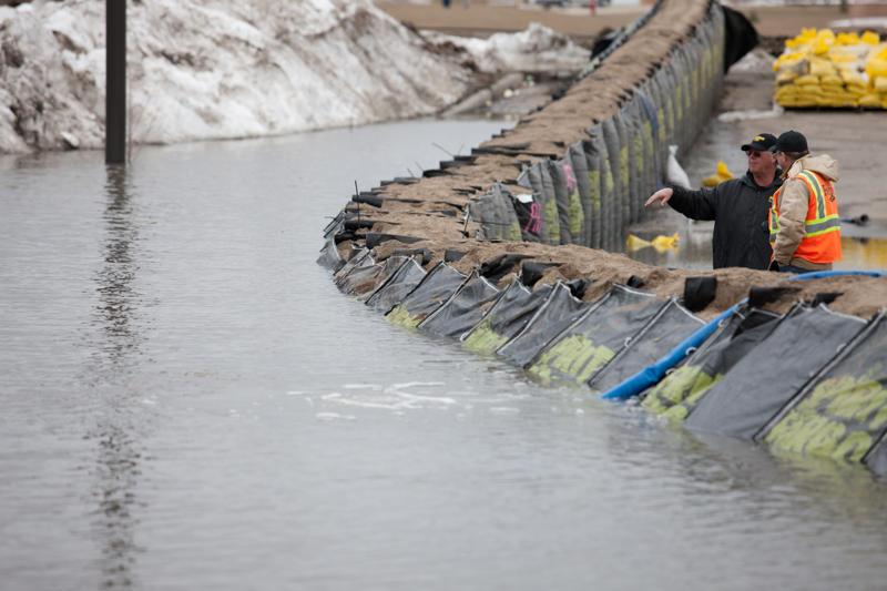
- TrapBag® barriers are a faster alternative to sandbags for flood protection and erosion control.
Self-supporting cellular design in 50-foot sections that connect end to end. - Designed to replace sandbags for natural and man-made disaster defense.
- Quick deployment, which matters most in the days before a storm.
- Lower cost than many other flood, erosion, and cofferdam options.
- Stays in place once installed, until you choose to remove it.
Uses include flash floods, storm surge, coastal and shoreline erosion, mudslides, levee reinforcement, and temporary cofferdams. Across California, the Gulf states, and the Southeast, that means flood lines that go up fast when the forecast turns. On the Great Lakes, it means shoreline protection through a winter with less ice. And with locations around the world, TrapBag can supply agencies and contractors in the regions abroad where this El Niño is expected to bring heavy rain.
Before any purchase, TrapBag provides consulting and project specifications to match the barrier to your site. Contact TrapBag to talk through your riverbank, shoreline, or flood-prone property, wherever it is, before the storms arrive.
Meet the author

Nick Fasano
Nick Fasano is Business Development Director at TrapBag®, where he oversees operations, growth strategy, and customer success. Since joining in 2018, he has helped lead projects across the U.S. and internationally, including deployments in Florida that protected infrastructure during Hurricanes Ian and Nicole.
Get the Dirt Before the Flood Hits
Stay ahead of flooding, erosion, and disaster response challenges. The Dirt, TrapBag’s monthly newsletter, delivers field-tested tips, real-world case studies, and the latest in barrier technology straight to your inbox.